The city as a map for machines
Niantic Spatial’s partnership with Coco Robotics reveals another layer of urban infrastructure: maps that help machines locate themselves among buildings, entrances and kerbs.
To a person walking down a street, an entrance is more than a coordinate. It sits on a particular side of a building, reached from a pavement, perhaps through a recess or beyond a change in level. A delivery robot needs to resolve those relationships too.
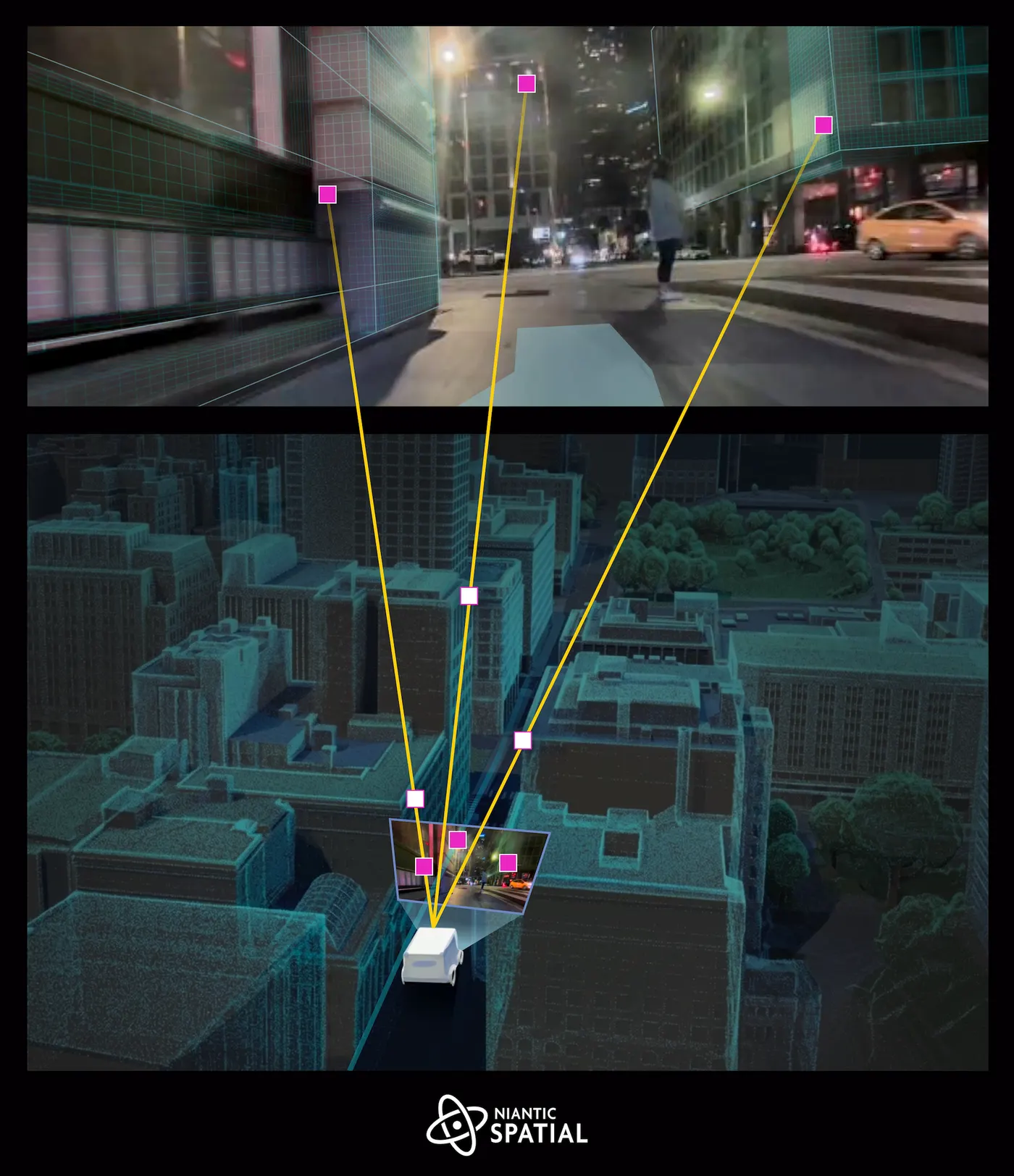
On 10 March 2026, Niantic Spatial announced a partnership with Coco Robotics to integrate its Visual Positioning System into the company’s delivery fleet. The collaboration targets accurate localisation in complicated urban settings, particularly where buildings interfere with GPS.
Visual positioning compares camera observations with mapped visual information to establish position and orientation. It addresses a specific problem: a robot may know its approximate location while still lacking the precision needed to reach the correct pickup point or approach an entrance from the right direction.

Niantic’s partnership announcement identifies urban canyons and locations without convenient kerb access among the challenges the teams intend to address. Positioning is one part of that work. Knowing where a robot is does not, by itself, determine whether a route is accessible or safe.
The company’s broader spatial model draws on a large collection of imagery. At its launch in May 2025, Niantic Spatial reported more than 30 billion posed images from millions of locations. That is the company’s account of its dataset, rather than independent evidence that every image came from Pokémon Go or that ordinary gameplay automatically involved scanning.
In a follow-up published on 16 March 2026, Niantic described both localisation and three-dimensional reconstruction as infrastructure for robotics. Digital models of actual places can also provide environments for simulation and context for human operators.
For architects and urban designers, the interesting issue is how machines interpret public space. A pavement, doorway or blocked kerb becomes part of an operating environment as well as a place people inhabit. This suggests new questions for street design: how delivery systems share limited pavement space, how they recognise thresholds, and how their digital maps keep pace with physical change.
Sources and image origins: Niantic Spatial and Coco Robotics, 10 March 2026; spatial infrastructure for robotics, 16 March 2026; Niantic Spatial launch documentation, 29 May 2025. Research lead: the reader-supplied X post.